May 19, 2010 Day 29 Let’s Go Shopping

Today we shop. PTCC wants to find a tote bag to carry her things in. (I call it a purse but that’s too girly for her). So we go to the Layton Mall to shop at JCP. We don’t find the one she saw online but we look around for other stuff. Eventually we walk into the mall to continue our search. This is a smaller mall about the size of the original Fashion Square in Orlando. We go from store to store looking at whatever she wants. This was probably the most enjoyable time I’ve ever had shopping with her. Usually I get nothing but an attitude when we shop together, something like I’m so out of touch with what’s cool. Eventually she finds some cool tennis shoes, a tote bag and we have lunch at Chick-Fil-A which she has been missing since we left home.

Then we go to Dollar Tree to look for some signs and stuff we’ve run out of, then over to the Walmart that we will have our oil changed at on Saturday before our trek to Yellowstone.

We are both missing CC and can’t wait for him to come back. It’s been weird sitting in one place for so long after traveling 3000 miles in 2 weeks. We have kept busy but I want to move on.

We met a nice couple from Panama City tonight while walking around the park. They full time 8 months of the year and have been here the same amount of time as we have. We talked for awhile about where we are going and doing and what we should see. They’ve been the first people we have talked to except for the managers because no one is around during the day. It seems weird with all these RV’s here and no one is ever home.

May 18, 2010 Day 28 A Lazy Day for Us

Today is all about doing nothing. And we did it well. We got up very late and made pancakes and bacon. Then sat around in our pjs until lunch. The weather was not the greatest since a low was coming through Utah bringing rain showers. PTCC went to the clubhouse to log on WebKinz and print some work for me. Then she came back and spent the rest of the day working on Spanish and watching TV and connecting with her friends. My day was spent reading, napping, and looking up info on Yellowstone and Grand Tetons. Can’t wait to get going again but this day of rest was nice after walking up to Timpanagos Cave yesterday. We spent the evening watching movies and catching up on personal things.

May 17, 2010 Day 27 Today I get Older and Want to go to My Cave

Today is LCC’s birthday and she is going to spend it in a cave.

I got breakfast in bed from PTCC. Only it’s not what you think. She was supposed to set her I-Pod to wake her up but she turned the volume down so when I woke up at 6 am she was still asleep. When I woke her up she got up and brought back some OJ in a bottle and a homemade concoction of granola bars and cereals in a bowl. Then she jumped back into bed and pulled the covers over her head. So I got up and made the coffee and some orange rolls and saw what she had worked on last night. She had strung red mini lights and Happy Birthday banners all over the RV. The table had all my Wildlife WebKinz and gifts from her, CC, and the G’s on it. I opened everything and then ate breakfast. CC called to wish me a Happy Birthday before we left.

By 8:20 am we are on I-15 going to Timpanogos Cave when the G’s call. I can’t talk because traffic is moving so swiftly and I don’t know where I’m going so we will talk to them later. We make it to the cave by 9 am and buy tickets for a cave tour at 10:30am. The brochure says it can take most people about 1.5 hrs to walk the 1.5 miles uphill on the path to the cave. We start out and it immediately becomes a tough uphill walk. The path is paved there are no stairs but it is tough. The trail is marked with ¼, ½ ¾, and end markers. It seems forever till we get to the ¼ mile mark. There is lots of snow on the rocks above the trail. PTCC had snow on her birthday in April and now I get it on mine in May. Will we ever get to warm weather? We stop a few times to take pictures and read the signs on the way. If I knew at the beginning they had a cell phone tour I would have called in to hear what it said but we didn’t notice it until about ½ way up the trail. We finally make it to the top in about 40 minutes and use the last chance bathroom before our tour. We are sweating and will now go into a cave that is 45 degrees. After everyone makes it to the top I notice the Ranger who will lead us. She looks very familiar to me. When I heard her speak I knew I had seen her before. I asked if she taught skiing at Snowbird and she said yes. I asked if her name was Nancy and she said it was. I told her she taught PTCC to ski 7 years ago when we stayed at Snowbird. A very small world it is.

Our tour starts and we get to go inside. We are paired up with a family of 3 generations that were in town for a wedding, a group of about 12 people plus us. The tour is very interesting but I don’t think CC would have liked it because of his size. There were many narrow cuts and low ceilings to get around. The cave runs beneath a fault line so it runs north to south. There were many formations that were beautiful to see. The main attraction is a large stalactite called the heart. They have lit it up with white and then red lights. Back in the 70’s they used to let people touch certain parts of the cave but no more since they have studied what it does to the formations. We finish our tour and get back out in the heat (70 degrees) to thaw out. The walk down is harder on the balls of the feet and my knees. None of the path is level you are always sloping toward the bottom of the valley. We make it to the bottom in 30 minutes and go into the Visitors center so PTCC can finish her Jr Ranger book and get her badge. We watched the movie and looked around in the bookstore. Then we got the picnic stuff from the car and walked a nature trail to the swinging bridge picnic area. This was a really nice lunch area. The American Fork River was gurgling nearby while we ate. It was nice and shady with the walls of the canyon above us and the river below. Miss Nancy had told us that this river had once flowed through the caves. It had to be a really long time ago because the distance between the two are so great now. We walk back to the car after eating and my phone dings signaling a message. I actually have 2-one from my brother and one from my dad, both wishing me happy birthday. I wait to call them back until I get out of traffic. We make it back around 3 pm and PTCC can’t wait to go swimming again. So we pack up and head for the pool where I call everyone back. After talking to my brother, father and the G’s, CC is calling to find out how our day has gone. I told him his package for me had arrived in good condition. He knows what I like. Inside the package was some dark Ghiradelli Chocolate as well as the Duke NCAA Champion T shirt and some new movies to watch.

PTCC is making dinner tonight. She worked up a menu on the computer that was completely in different foreign languages. I got to chose what I wanted to eat from appetizers to entree to 2 separate desserts. I think this has been a great birthday except CC wasn’t able to spend it with us.

May 16, 2010 Day 26 Want to See Mine?

Today I let PTCC sleep as late as she wants, so she does until 9am. Yesterday we were considering the idea of going snow skiing at Snowbird. They are open Fri, Sat, Sun until Memorial Day. But after we looked at the price of a ticket ($69) and the cost of boots, skis, and poles. It didn’t add up when I found out they would only be open to 2pm and ½ the mountain was inaccessible. PTCC also thought it might be too icy for her. But it would have been cool to say I skied for my birthday this year.

So instead we decided to go to the Bingham Canyon Mine which is the largest copper mine in the world. It can be seen from outer space.They also mine other minerals but copper is the largest. We get going but Nuvi doesn’t put me on the interstate, instead I’m driving down Redwood Rd which is very industrial and doesn’t feel too good to me. It keeps routing me on these small roads and I wonder if we’ll ever get there. It didn’t help that Nuvi wouldn’t accept the Mine address so I put a generic one in. Well we get to a cross road and I still can’t get the Mine to come up so I call CC to have him Google it for me. He has to call me back since he was actually doing chores. At least I know everything is being taken care of back home. So CC tries to help us get to the Mine and PTCC says he has to say everything just like the Nuvi does. He helps us get to a very desolate looking area that we determine is the mine because the mountain is orange instead of brown. A guard greets us with “$5 per car” instead of “hello”. We have to drive 4 miles straight up the mountain to get to the visitors center. We finally get there and see the big pit. We go into the visitors center and check out the displays. I didn’t know that Kennecott had their hand in so many things in our homes and lives. Almost everything you use on a daily basis has passed through this company somewhere. They also made the Olympic Medals for the 2002 Winter Games. We finish looking at the displays inside and then walk outside to the pit overview. This area used to be a very large mountain. Now it is a mountain in reverse down into the ground. There are people working even on a Sunday. I think I read that it is in operation 24/7 whenever weather permits.

We then go to the gift shop and look around. It was tight because a tour bus had gotten to the Mine just before us so the shop was crowded. We looked around and got a small charm and a copper postcard.

We then had lunch in our car as there was no place to picnic and started back down the mountain. We had let CC go earlier so I was hopeful we could find our way back since we had a definite address to go to. Once again we were routed through odd places on the way back. But we did make it finally.

After putting everything back in the RV we are going to Walmart to pick up our pics from last Monday and get my birthday cheesecake. After shopping I tried Nuvi again and it wanted me to go on a side street when I knew the I-15 would be faster. Then I remembered that I had set it on bicycle yesterday when we went to see the capitol and then walked to Temple Square. So I changed it back to car and it reset and took me on the interstate finally. That’s good because tomorrow we are going to a cave down south and I want to take I-15 South so hopefully this has fixed it.

PTCC goes to the computer area when we get back and I fix some meals for the future and then go to the clubhouse as well. We print my reviews so I can put them in our camping book for future reference. Then PTCC changes and we go out to the pool. As I’m sitting there CC calls for his nightly check in. He tells me that our Sunday School class wanted to call me early this morning and sing “Happy Birthday” to me. Little do they know I planned to be away on purpose so they wouldn’t this year (ha, ha). PTCC has to share the pool with 2 others today. It felt very nice outside even though it was only 72 degrees. The sun felt hot and the water was warm. We enjoyed it until 5:45 pm when the managers tell us the pool closes at 6 pm. So we pack it in and PTCC goes to get her shower while I prepare dinner for us. It will probably be a quiet evening tonight because tomorrow’s my birthday and I’m sure we’ll party all night long.

May 15. 2010 Day 25 Mormons, Mormons, Everywhere

Today we head out for the Utah State Capitol situated a a very high hill. This is the most beautiful building I have seen in a good long while. The entire building inside and out is marble. It was designed after the US Capitol. After seeing the FL state capitol in TLH this one puts it to shame. The entire building is open to visitors without having to go through security lines to ruin the look. There are wonderful murals of the Mormons moving West painted on the walls and ceiling. Even the elevator was made of marble and glass. After looking around to our fill we depart for the Temple Square. The walk down was nice because it was going down the hill. After 3 blocks we come to a beautiful block with the Temple as its centerpiece and various buildings around the square. The flowers are in bloom, water is running in the fountains, all is right in the world. We look around and go into the South Visitors center and take in how the temple was built. The Mormons put in a lot of backbreaking labor to get it done. We walk across the square and get stopped by some female missionaries that want to tell us all about their religion and the different buildings in the square. We talk for awhile and then move on to the Assembly Hall and then the Tabernacle where the choir sings with an organ that has 11,683 pipes. We move on to the North Visitor center which tells the story of Mormonism through vignettes and statues as well as 2 one hour films. We play around with the family history computers by looking up my mom and my older brother both who died within the last 2 years. They were both in there as well as millions of others going back about 100 years or more. After that we decide we are hungry so we head back to the car which we left at the state capitol. We have to walk at about a 45 degree angle up 3 blocks to get there. Utah is no place for a flatlander like me to drive. We must have gone over at least 4 blind hills today.

I tell PTCC that we will eat when we get to the Olympic Park. Unfortunately we couldn’t find it and they were doing road construction so where the GPS wanted me to turn there was no way to do it. So after 3 tries of finding it we gave up and headed to This Is the Place.

It is a state park where it details the journey of the Mormons and the community they built once they were here. We visited several of the buildings that had interpretive speakers in them. We visited a family cabin, shave shop, mercantile, hotel, stable, blacksmith and the schoolhouse. They were having a big March of Dimes event so we were lucky we didn’t get there early because it looked like parking would have been a problem, since cars were parked all over the curbs. We talked to the young lady who was in the schoolhouse for awhile about the settlement and how they grew crops.

After that we decided to give the Olympic Park one more try. PTCC finally saw the cauldron we were looking for. It was just a matter of getting there. After one more go around we finally make it into a parking lot. It looks like the former Olympic Stadium now belongs to University of Utah. The flame stand was there but there was no flame or water running down it. And the Olympic Arch looked kind of sad as well when it’s not turned on. Hopefully the University lights them up for their games in the stadium. PTCC and I went into the building and saw a short movie about the 2002 Winter Olympics and then walked around and looked at the displays in the lobby. After that we decided we’d had enough for today and went home. Our Nuvi took us down this very industrial path to get us back to Redwood Rd. I really thought we were being lead down a wrong path but it worked out in the end. Stopped in the office to check to see if my birthday package had arrived, but not yet. I will have to wait until Monday it seems.

PTCC couldn’t wait to get to the office to play on the computers so LCC took a short nap and then went to the office to see if PTCC wanted to swim. The temperature is still around the mid 60’s but the sun is shining so it seems hot if you are out of the wind. So I sat near the pool while PTCC swum and then we came back to fix dinner and end our evening.

May 14, 2010 Day 24 One of us Bikes the Other Doesn’t

Well after a slow start to our morning LCC gets ready to bike part of the nature trail next to the park. Her mistake was telling PTCC that the trail was 14 miles long. Now she doesn’t want to go because she thinks we are doing the whole thing. I can’t convince her otherwise. So she stays behind and does her Spanish work and I get my bike ready. In all the conversation I forgot my helmet which I rarely go without after having a bike accident in my high school years. CC and PTCC also have had bike accidents with PTCC’s being the worst since she lost her front teeth. I mention this because everyone I saw on the path had their helmet on. In FL you do not see adults wearing helmets. Most of the time CC and I get weird looks when we are out biking as a family, because everyone knows the kids have to wear them but why would you as an adult??

The bike path was nice and paved once you leave the park property. It does have some inclines and fronts the interstates but is a nice path overall. At mile 1 there is a parking area to access the trail and every ½ mile and mile is marked by signs. I only went about 2 miles out because I did not want to leave PTCC alone too long so I turned around and went back. Good thing I did because about 20 minutes after getting back thunderstorms rolled in with lightning.

So we spent most of the day on the computer and reading about Yellowstone so we know what to do when we get there.

At 4 pm PTCC wants to go swimming so we head to the clubhouse and she goes in. I tried to sit outside but it was windy and cool so I watched her inside the laundry room that has a nice big window overlooking the pool. The pool is heated and salt water so she stays in about 45 minutes, but gets cold when she gets out.

We head back to the RV and LCC takes a nap while PTCC goes back to the clubhouse to use the computers there. In the afternoon the wi-fi seems to get real slow and it’s hit or miss if you can get on or not. So I make sure she does her schoolwork in the mornings when the reception is better.

CC calls and tells us about his day and we do the same. It feels like he went on a business trip and is away for awhile (but it’s really us that are gone-seems strange).

Tomorrow we will head downtown Salt Lake City and see what’s there.

Photo Update

I plan to try and go through and update the all the post (mine and Lady CurbCrusher’s) with links to the pictures. But since that will take some time, here are links to the pictures and a couple of videos that we’ve taken on the trip in reverse order of the trip.

Leg 5 – Yosemite to Salt Lake

Pony Express RV Park

Double Dice RV Park

Stop 3 – Yosemite

Yosemite – The Valley

Yosemite – Happy Isles

Yosemite – Hetch Hetchy

Yosemite – Vernal Falls and…

Yosemite – Bridal Veil Falls

Yosemite – Wawona

Yosemite – Yosemite Falls

Yosemite – Campgrounds

Leg 4 – Grand Canyon to Yosemite

Sequoia and Kings Canyon…

Visalia KOA

Desert View RV Park Needles

Stop 2 – Grand Canyon

GCNP – Bright Angel Trail

GCNP – Hermits Rest

GCNP – Hopi Point

GCNP – Powell Point

GCNP – Maricopa Point

GCNP – Trailview Outlook

GCNP – Grandview Point

GCNP – Moran Point

GCNP – Tusayan Ruin

GCNP – Lipan Point

GCNP – Navajo Point

GCNP – Desert View

GCNP – Grand Canyon Village…

GCNP – Mathers Point

Trailer Village at Grand…

Leg 3 – Vicksburg to Grand Canyon

Wuptaki National Monument

Petrified Forest National Park

Amarillo to Holbrook April…

Amarillo April 2010

Leg 2 – Pensacola to Vicksburg

Jackson-Vicksbu rg April 2010

Leg 1/Stop 1 – Orlando to Pensacola

Pensacola April 2010

GART – Leg 5 – Yosemite to Salt Lake City

Time for the final leg on the first part of our trip. We have to leave Yosemite and head to Salt Lake City. I had been worried about the drive into and out of Yosemite for some time. I’d posted on irv2.com and canvased everyone in the campground about how to leave. The general consensus was that we should go down CA-140 and the to CA-99 and to I-80 to head to Salt Lake City. I ended up choosing to go down CA-120 to exit Yosemite, and had no problems. I actually found driving CA-120 out of Yosemite easier than driving CA-41 into the park. There was a good sized climb to Crane Flats as your leave the park, but the motorhome handled it with no problems. There was a bunch of downhill driving, but the grade brake did the job and kept us in control. The nice part was that CA-120 was wider and had more room on the sides (even a bit of a shoulder) that CA-41 did. The “worst” part, the one that everyone warned me about was Priest Grade just west of Groveland. This grade is steep, and has a number of switch backs, but there seem to be good straights between the switchbacks, so it doesn’t feel as right-left-right-left as CA-41 did on the way in. As we exited Groveland, I let the grade brake work until about half way down the grade. I had a couple of people that had built up behind me, so I pulled into a pull-out and let them pass. Then I manually shifted to 2nd and finished going down the grade.

The mistake I made was at the split of CA-120 and CA-49. I had considered continuing up CA-49 to US-50 to cross the Sierras, but I choose to follow CA-120 to CA-99 then go north to Sacramento to catch I-80 and go over Donner Pass. I think my time to Reno would have been about the same, maybe even a little better if I’d just gone up CA-49. Instead I had the “pleasure” of dealing with city traffic around Sacramento, which was a pain. Much less fun than driving in and out of Yosemite.

We pushed on for a twelve hour day and ended in Elko, Nevada for the night. We stayed at the Double Dice RV Park (our pics), which is a big gravel parking lot with hookups. We were there about 14 hours, so no complaints, we got what we wanted: electricity and water.

We spent another four hours on Mother’s Day driving from Elko to Salt Lake City. There are 410 miles of I-80 in Nevada, and they are a lot of nothing. We came up with two new state “nicknames” for Nevada based on our I-80 experiences: The Bush State and The Prison State. Lady CurbCrusher noted that there are no trees along the interstate, just a lot of bushes. The other thing that is prevalent along I-80 are signs that read “Enter Prison area. Do Not Pick Up Hitchhikers. Emergency Stopping Only.” It seemed like about every 60 miles you would see one of these signs. I never realized that Nevada had so many prisons.

We reached the goal of the Pony Express RV Resort (our pics) in Salt Lake City on Mother’s Day afternoon. Lady CurbCrusher had to ride for a while, but we were early enough to go out had have a dinner and relax for a while. That completes about 3700 miles of our Great American Road Trip. Just over half of the 6600 miles that we think we are going to travel. We are also headed back to the east. We spent so much time headed west, that I tried to get on I-80 west in Sacramento. Lady CurbCrusher pointed out that I wanted I-80 EAST, and I wanted to argue until I realized that as usual, she was right.

GART – Stop 3 – Yosemite National Park – Vernal Falls Mist Trail

Lady CurbCrusher has done a great job of describing how we spent our time in Yosemite. The only time we did different things was when the ladies went horseback riding and I went hiking. I would have liked to go horseback riding also, but they had a weight limit, and ol’ CurbCrusher exceeds the weight limit by about twenty pounds. I choose to hike to Vernal Falls instead.

I rode my bike to the beginning of the Mist trail, right before you get to the Happy Isles Nature Center. Starting up the trail is a bit
deceptive. It is a bit of a steep climb, but the trail is paved and wide enough for people to pass. The trail continues like this all the way to the Vernal Falls Footbridge, the first place that you can view Vernal Falls from. It was a bit taxing to hike up the hill, but I took my time and drank lots of water. The views of the Merced River and other falls are beautiful, as are most of the views in Yosemite.

After the break at the Footbridge, I decided that I would continue to the top of Vernal Falls on the Mist Trail. As soon as you leave the Footbridge, the nature of the trail changes. It appears that for the first few yards that the trail uphill of the bridge used to be like the trail on the other side, but it quickly becomes a broken ground with scattered rocks, not the smooth pavement you were on. As the trail climbs, it deteriorates to basically a trail. You finally come to point, where there really isn’t a “trail.” That’s because steps that have been carved out of the hill replace the trail. The steps are not the nice evenly spaced steps of a stairwell, no some are two to two and a half steps high, and some are like a baby step. As these steps start, you also find yourself getting soaked with a cool mist from the falls. As you climb up, you walk through rainbows, and see numerous rainbows throughout the mist. You finally get to a point where the “trail” narrows to about one person wide, and there is a rail on the outside. This section is a mixture of carved out steps, and just uphill walking on rocks. Finally, your emerge into the sunshine at the top of the falls.

This climb is great. As you go up the steps, you are right next to the waterfall. You can hear it and feel it. From the top you can look down as the water plunges over the granite side of the cliff. As with everywhere in Yosemite, the view from the top was great back into the valley. It was a great experience to climb to the top of Vernal Falls.

The trail continues to another falls, Nevada Falls. However, since I wanted to get back and meet Lady and Little CurbCrusher after they finished their horseback rides, I headed back down the trail. Something that I didn’t notice on the way up was that a number of the steps carved into the granite were sloped back towards the back of the step. Going up that didn’t make much difference, but coming down it was noticeable. I took about the same amount of time coming down the upper part of the trail as I did climbing it, but the lower part of the trail only took about two-thirds of the time to descend.

All in all it was a great way to spend a morning. I was not cold like the horseback riders (see Lady CurbCrushers account of the riding), I was working up a sweat. The views and the experience were great. I wish I’d had time to hike more of the waterfall trails in Yosemite.

The pictures from my hike are here.

GART – Leg 4 Grand Canyon to Yosemite

I’m way behind in my comments. I’ve been trying to catch up on getting the photos posted, and of course Lady CurbCrusher is doing a great job of keeping everyone up to date on what we’ve been doing each day. I’ve changed to just limited my comments to the driving and the stuff that I do, of think needs to be added to her comments. So to catch up, here are my thoughts from the past week or so.

The fourth leg of our trip was scheduled to be from the Grand Canyon to Yosemite National Park, a distance of about 700 miles, with a stop in the Fresno area so that we could visit Sequoia and Kings Canyon National Park before finishing the trip to Yosemite. Because we had done everything that we had planned in the Grand Canyon, we started out a half a day early and broke up the trip a little more. We left the Grand Canyon around noon and headed down AZ-64 to Williams which is located on I-40. We stopped in Williams to fill up the tank (the most expensive gas on the trip so far) and then drove as far a Needles, California.

The drive on I-40 was uneventful. The road seemed in fairly good shape, until we got to California. The first 15 miles of so of I-40 in California seemed to maintained in a manner that makes one want to turn around and leave California. Interestingly enough, there is no welcome station in California, but there is an “inspection station” where some guy (or gal) ask you if you have any fruits and vegetables in your vehicle.

After about 230 miles we stopped in Needles at the Desert View RV Park (our pics). This was a very nice park, something about it made me want to just stay for a week or so. Maybe it was the fact that for the first time in four or five days the temperature was in the 80s. The park has a mixture of gravel and concrete roads, and full hook-ups (water, sewer and electric) at the sites. Sites are separated by an oleander hedge that runs the entire length of the site, making for a private setting. There is a pool and laundry facilities making this pretty much a full service RV park. The host were friendly and talkative, and we even met the owners a little later in the evening.

One thing we have noted as we’ve headed out west is the abundance of rental RVs. El Monte, Cruise America, Chepa Campa, and so on. It appears that a lot of these are rented by Europeans and they visit the parks and sites of the American West. I know in our camping in Florida and on the east coast, it seems like we rarely see a rental RV. But, every park we’ve stayed in out west seems to have had a least half a dozen of them.

We slept in a little the next morning and then headed up to Visalia, California, another 350 miles closer to Yosemite. The drive was on I-15 to Barstow, then CA-58 to Bakersfield and CA-99, which heads north to Visalia. While I-15 seemed to be in good repair, the cross winds between Needles and Ludlow made this one of the more white-knuckle driving experiences of the trip. It was even worse that the winds had been in Arizona when we had been driving between Winslow and Flagstaff. CA-58 from Barstow to Bakersfield was a nice drive. The road goes back and forth between a four-lane and two-lane highway, but is smooth enough and there are not a ton of little towns that slow you down. The final stretch was up CA-99, which is a four-lane limited access highway that runs through town after town. All the merging gets a bit tiring, but the road is decent for the most part, and was not too crowded.

We finally ended up at the Visalia KOA. It was a typical KOA, it had a pool, propane, playground, pull-thru sites with full hook up. Nothing exciting or overly attractive about it, but nothing that made you want to leave either. It was located in an industrial area, but that was not a big detriment. The sites were big enough to put out slides and the hook ups were close enough to use the short water hose. (Our pics)

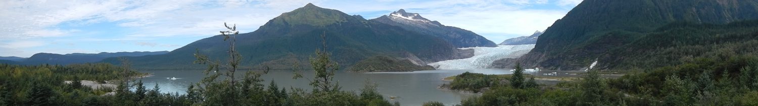
We used the stop in Visalia to take a “rest” day and visit Sequoia and Kings Canyon National Park. The park is located about 60 miles from the KOA. We visited the park in a loop, driving east on CA-198 to the entrance to the park, then through the park. We returned on CA-180 west and then headed south on CA-63 to finish the loop back to Visalia. We took most of the day to complete the trip, and Lady CurbCrusher has documented our activities and such in the park, and our pics are here.

The final drive of this leg was from Visalia to Yosemite Valley, an approximately 130 mile drive. We choose to approach Yosemite from the south heading up CA-41 into the park. When we left the KOA in Visalia, Lady CurbCrusher entered the destination in the GPS as Yosemite National Park. This caused the GPS to show that we had only about 95 miles to drive, which made me ecstatic. As we headed up CA-99 and then switched onto CA-41 the driving was not bad. The road was wide, not much climbing. When the GPS showed about 36 miles left, the road got a little narrower. When we got to about 17 miles left, we started climbing and turning a bit. As we went on, the road wound around and climbed more, with little drops here and there. When we reached the entrance station, I was a bit disappointed, I still had about 35 miles to drive. We stopped at Wawona and had some lunch and then continued on to the Yosemite Valley. CA-41 through the park is a bit of a pain. It winds a lot, not switchbacks, but lots of curves (you turn left, then right without any straight-away in between), and the road is narrow. There are just the two lanes, no real shoulders. Lady CurbCrusher was convinced that I was going to hit the motorhome mirrors on the snow poles that are on the side of the road. She also didn’t like that the curves on the road were banked,
so that as your turned into each curve, the motorhome leaned a bit. All in all it wasn’t too bad, the downhills take some getting used to, but the grade brake in the motorhome worked as advertised, so I didn’t have to ride the brakes.

Finally, we get to THE tunnel. The sign says 10 foot 1 inch at the curb. I’ve read that motorhomes and busses have no problem getting through this tunnel, but still this is scary. I stayed as close to the center line as I could in the tunnel, and you can tell that the sides go higher at the side of the road, but there are still rocks sticking out in the tunnel that cause you to pause. We finally emerged from the tunnel in the valley, seeing the famous tunnel view for which Yosemite is known. Now it was just a matter of finding the campground, which was at the other end of the valley. Since the valley speed limit is 35, it takes a while to get to the campground and check in.

The campground we are in is Lower Pines. There is also Upper Pines and North Pines. Of the three, Lower Pines seemed the least crowded. We fit in our site with a bit of a problem. The length was fine, but we were not able to put out the living room slide because of the tree that was right next to the site. There are no hook-ups, so there are no hoses or wires to worry about. You are allowed to run your generator for 45 minutes at a time, up to two hours a day. That was plenty of time to charge the batteries and keep the rig running fine. Pictures of the campground are here.